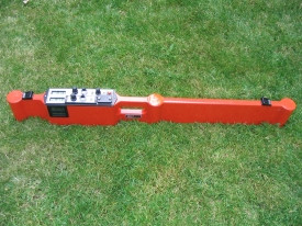
Electromagnetic Geonics EM-38 MKII with simultaneous conductivity and in-phase measurements at two depths.
#101143
The EM38-MK2 provides measurement of both the quad-phase (conductivity) and in-phase (magnetic susceptibility) components within two distinct depth ranges, all simultaneously, without any requirement for soil-to-instrument contact. With a maximum effective depth of exploration of 1.5 m, applications in agriculture, archaeology and general soil sciences are common.
The standard EM38-MK2 includes two receiver coils, separated by 1 m and 0.5 m from the transmitter, providing data from effective depth ranges of 1.5 m and 0.75 m respectively when positioned in the vertical dipole orientation, and 0.75 m and 0.375 m respectively when in the horizontal dipole orientation.
New coil technology, supported by temperature compensation circuitry, markedly improves temperature-related drift characteristics as compared with the preceding generation of EM38 instruments.
An optional, collapsible calibration stand supports automation of the instrument calibration procedure. Once positioned within the stand, the instrument can be calibrated within seconds, without any requirement for iterative adjustments.
Supporting both walking and trailer-mounted survey methods, external power sources can be connected to the instrument for extended field operations; an optional, lightweight, rechargeable battery pack provides for 25 hours of continuous operation. Also for trailer- mounted operations, a protective capsule, constructed of durable plastic materials, is available as an option.
Data collection is supported by the Juniper Systems Archer, or other appropriate field computer, connected by either RS-232 serial cable or Bluetooth wireless technology.
47 x 16 x 10 inches
54 lbs
$100.00
$95.00
Ask a question about this item
*(Does not include shipping or insurance)